
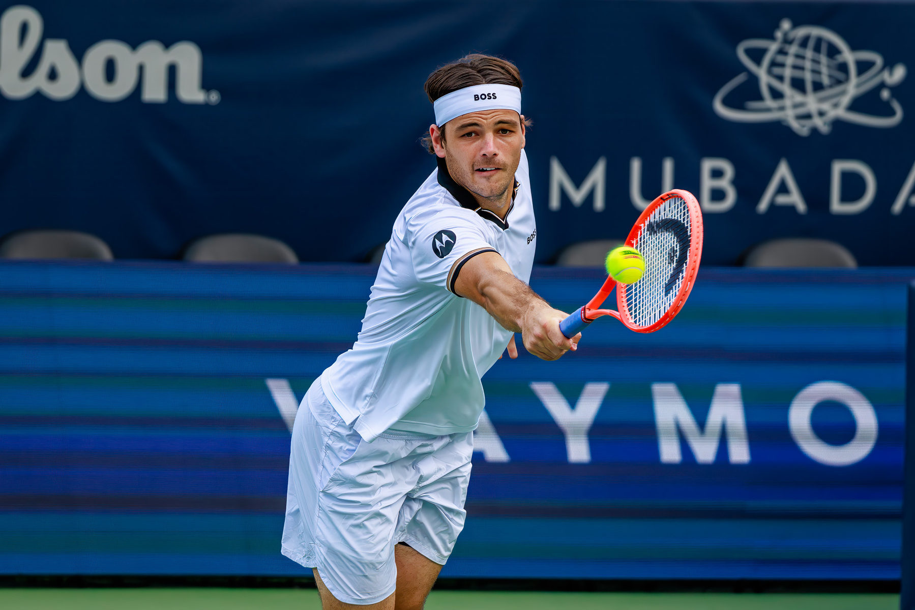
Taylor Fritz | DC Open 2026
World No. 10 Taylor Fritz locks his eyes onto the ball just a split-second before string bed contact during his opening round match at the 2026 DC Open.
Fritz, seeded No. 3 in the tournament, kicked off his campaign on July 27, 2026, with a sharp, straight-sets victory over Belgium’s Zizou Bergs, taking the match 6-3, 6-4 on Rock Creek Park’s Stadium Court.
Emma Navarro | 2026 DC Open
Emma Navarro returns a backhand during her first-round match against Sofia Kenin at the Mubadala DC Open in Washington, D.C., on July 27, 2026. Seeded No. 8 in the tournament, Navarro won the match 6-0, 7-5.

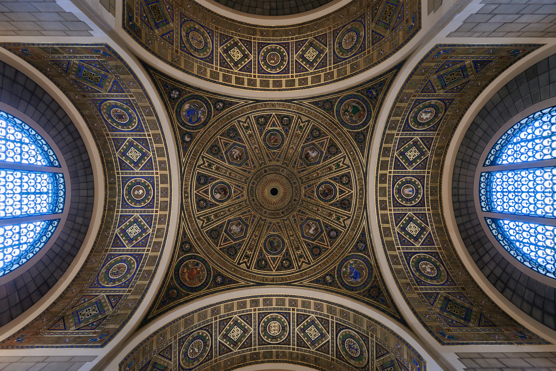
Temple to Science: The Great Hall Dome, National Academy of Sciences, Washington, DC, 2026
The centerpiece of the National Academy of Sciences building in Washington, D.C., the Great Hall was designed by the esteemed architect Bertram Grosvenor Goodhue and dedicated in April 1924. This stunning interior dome is the hall’s signature feature, intended to evoke the grandeur of a classical Byzantine cathedral repurposed for the exploration of the natural world.
The intricate art in the dome was executed by the artist Hildreth Meière using Guastavino structural tile, which provided both structural integrity and a shimmering surface for her intricate mosaics. The Great Hall and its dome function as a visual encyclopedia. At the center is the Sun, surrounded by astrological signs and figures representing the four classical elements. A significant detail is the bronze text encircling the dome, which reads: “TO SCIENCE, PILOT OF INDUSTRY, CONQUEROR OF DISEASE, MULTIPLIER OF THE HARVEST, EXPLORER OF THE UNIVERSE, REVEALER OF NATURE’S LAWS, ETERNAL GUIDE TO TRUTH.”
The smaller, blue stained-glass windows depicted in the image are designed to give the illusion of open sky, reinforcing the concept of the hall as an open-air observatory.
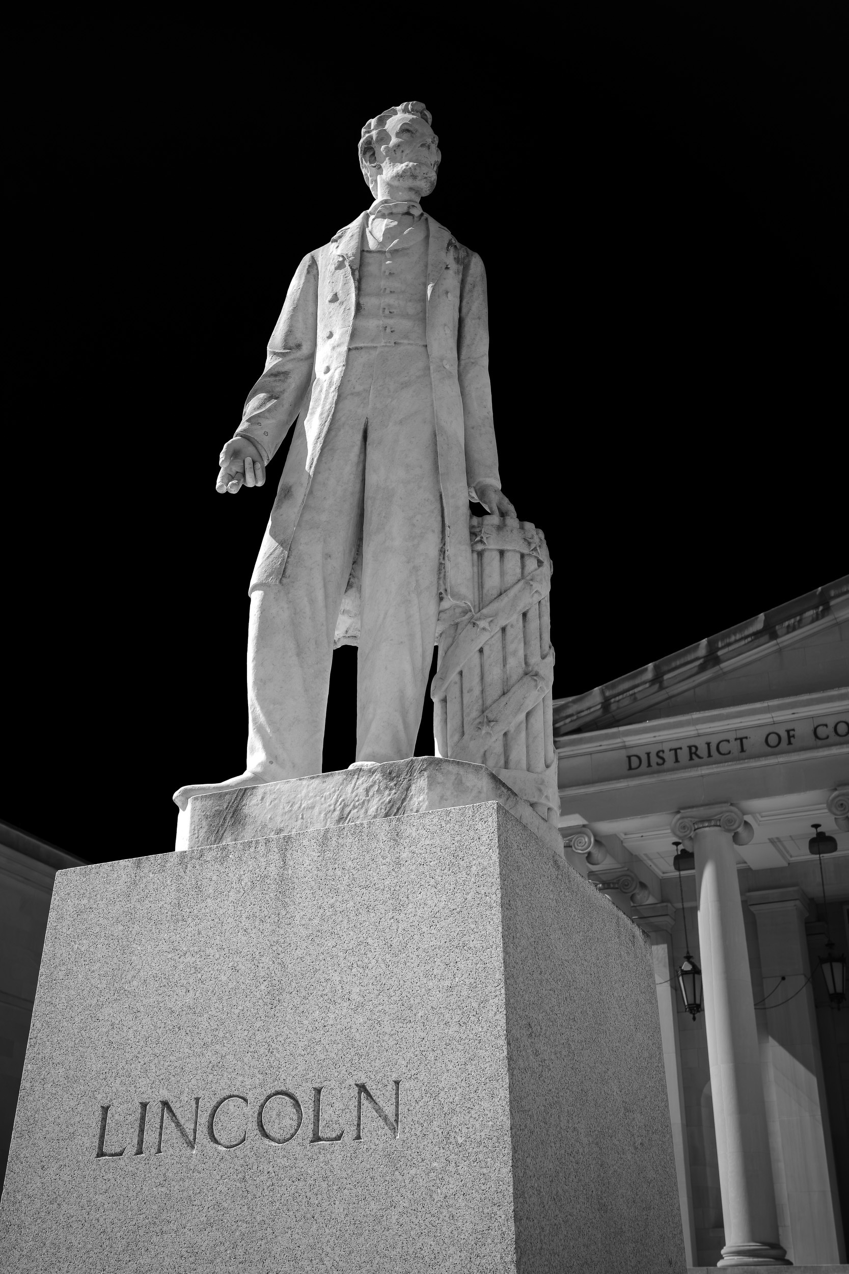
First in Union: The 1868 Lincoln Statue at Judiciary Square
Standing outside the Historic Courthouse (now the D.C. Court of Appeals) in Judiciary Square, this marble figure of Abraham Lincoln is the nation’s oldest extant public monument dedicated to the 16th president.
Unveiled on April 15, 1868—the third anniversary of Lincoln’s assassination—it predates Daniel Chester French’s famous seated statue at the Lincoln Memorial by 54 years. The sculptor, Irish-American artist Lot Flannery, had known Lincoln personally and was actually in the audience at Ford’s Theatre on the night of the shooting.
Flannery portrayed Lincoln in classic oratorical posture as a statesman and lawyer, his left hand resting on a fasces symbolizing the preservation of the Union. Originally erected on a high column to place the president safely above reach, it was moved to this lower granite pedestal in 1923 following courthouse expansions.
Flannery’s statue was funded largely by grassroots donations from local Washington citizens shortly after the assassination. It represents a city’s immediate, localized grief for a president they had seen walking their streets just years before.
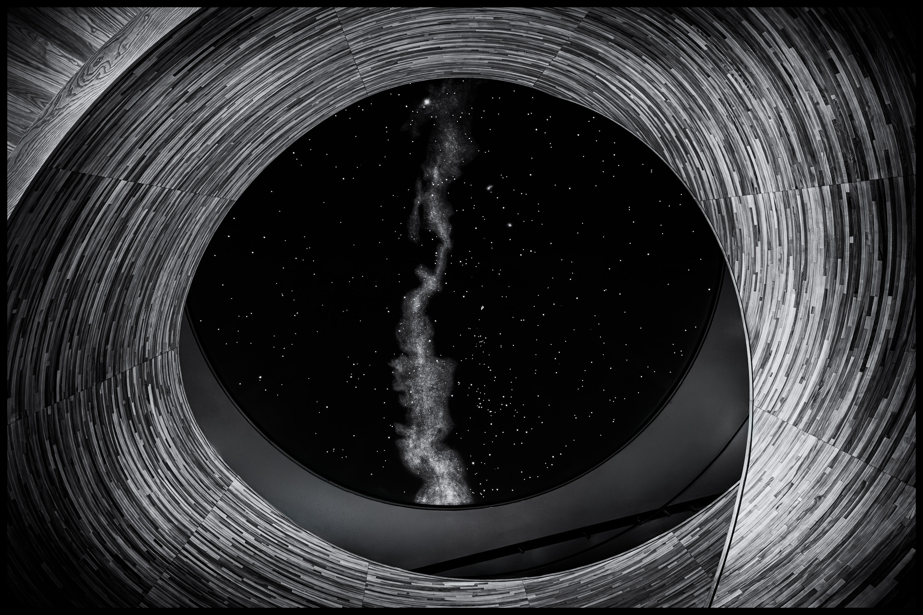
Window to the Cosmos
Looking up through the circular ceiling of the newly opened National Geographic Museum of Exploration in Washington, D.C.
The Reality of the Infinite Web
There is a disconnect between the sheer volume of writing published online and who actually sees it. If you have ever felt like your personal blog is a quiet, isolated corner of the internet, the data shows you are in very good company.
Across the estimated 600 million blogs that exist globally, industry tracking indicates that fewer than 10% of all blogs generate consistent organic traffic. We tend to see the massive success stories anchoring our feeds, but the vast majority of publishing happens in near-total anonymity.
To make the scale of this even clearer, data from a massive index study by the SEO authority Ahrefs reveals a stark threshold for independent domains:
- When you look strictly at websites categorized as blogs, an astonishing 99.93% of blog sites receive fewer than 1,000 visitors per month.
- Only a microscopic 0.07% ever cross that 1,000-visitor line.
You can explore the broader study on how these search dynamics function directly via the Ahrefs Blog.
A Shift in Perspective
For a personal project or an independent portfolio, this isn’t a failure—it’s a clarification of purpose. The internet’s search ecosystem is structured like a winner-take-all game optimized for massive media farms, corporate backlinks, and algorithmic boxes.
When you stop writing for search engines, you get to write for the exact group of people you want in your space. A tiny, intentional audience who types your URL in directly or follows your RSS feed is infinitely more valuable than a thousand accidental clicks from Google anyway.
Why Write?
This post gets at something I’ve never quite been able to say:
When I think about what I wish to accomplish if I knew I was going to die, apart from spending time with my loved ones I think only writing is left. It is a way of emptying myself I guess, a way of sublimating my sad existence. I wouldn’t pretend that my writing is useful, but at least it will be a window into an interior world that doesn’t exist anywhere else.
Is more visibility always good?
Blogs don’t have the important place on the internet today that they once had; I know that perfectly well, and I don’t care. Those who are genuinely interested in what I have to say can find me here on the open web.
A Reference Guide to Holocaust Resources
I put this list together for myself over the years, as a place to keep track of the archives, timelines, and books I trust most. As the child of Holocaust survivors, I’ve spent a lot of time looking for source material I can rely on, and I’m sharing it here in case it’s useful to someone else doing the same.
As the United States Holocaust Memorial Museum explains, the Holocaust was the systematic, state-sponsored murder of approximately six million Jews by Nazi Germany and its collaborators. The Nazis, who took power in Germany in January 1933, considered Jews a racial threat to be eliminated. In 1933, Europe’s Jewish population stood at over nine million; by 1945, nearly two out of every three European Jews had been killed. Other victims of Nazi persecution included an estimated 200,000 Roma, and at least 200,000 disabled patients murdered under the Nazi euthanasia program.
Curated Holocaust Archives & Libraries
- U.S. Holocaust Memorial Museum, including its Holocaust Encyclopedia
- Yad Vashem
- USC Shoah Foundation
- Arolsen Archives – International Center on Nazi Persecution
- The Wiener Holocaust Library
- Yale’s Fortunoff Video Archive for Holocaust Testimonies – more than 4,400 testimonies comprising 12,000 recorded hours of videotape
- From Numbers to Names – explore Holocaust photo and video archives through AI
- LastSeen Image Atlas – images of the Nazi deportations
- The World Society of Częstochowa Jews and Their Descendants
- Jewish Records Indexing – Poland – safeguards the evidence of the 1,000-year Jewish presence in current and former Polish territories
Holocaust Remembrance Days
- Yom Hashoah, designated by Israel, marking the anniversary of the Warsaw Ghetto uprising
- International Holocaust Remembrance Day, designated by the United Nations, marking the liberation of Auschwitz
Timelines
- Timeline of Events – U.S. Holocaust Memorial Museum
- Timeline – Yad Vashem
- Timeline of the Holocaust: 1933–1945 – Museum of Tolerance
- Events in the History of the Holocaust – The Wiener Holocaust Library
Books
- The Rise and Fall of the Third Reich: A History of Nazi Germany by William Shirer
- Nazi Germany and the Jews, Volume 1: The Years of Persecution, 1933–1939 by Saul Friedländer
- Nazi Germany and the Jews, Volume 2: The Years of Extermination, 1939–1945 by Saul Friedländer
- KL: A History of the Nazi Concentration Camps by Nikolaus Wachsmann
- The Holocaust: An Unfinished History by Dan Stone – reviewed in the New York Times
Last updated: June 16, 2026
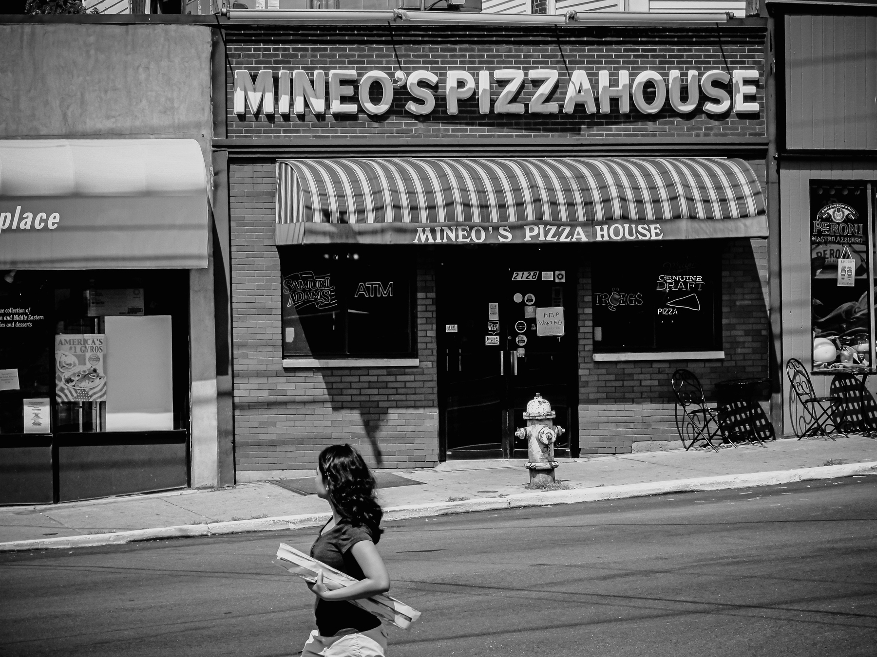
A Taste of Squirrel Hill in the Washington Area
I grew up eating Mineo’s pizza in Squirrel Hill, Pittsburgh. About once a week my father brought home a fresh pie—a real treat, and a legend at Taylor Allderdice.
The story behind it is pure Pittsburgh. Giovanni Mineo arrived from Sicily in 1954, the year before I was born, where he’d worked as a baker. Riding a streetcar down Murray Avenue one day, he spotted an empty storefront at 2130 Murray and claimed it. On September 13, 1958, he opened Mineo’s Pizza House in what was then a mostly Jewish neighborhood—and earned its loyalty, closing every year for the major Jewish holidays. These days, when I want a taste of home, I drive to Giuseppi’s Pizza Plus in Rockville. Walk in and the Steelers memorabilia covering the walls tells you everything.
Sue Feldman opened Giuseppi’s in 1990 with her sons Scott and Eric—all Pittsburgh natives. Scott grew up in Squirrel Hill too, and went to Allderdice like me. But here’s the twist: the recipe isn’t Mineo’s. It comes from Mineo’s old rival, Aiello’s.
Scott worked at Aiello’s as a teenager—a pizzeria Joe Aiello opened in 1978 after leaving Mineo’s himself. When Scott and his mother started Giuseppi’s, the Aiello family mentored them and passed along that same rich, herb-laced, slightly sweet sauce. It’s still what’s in the pies today.
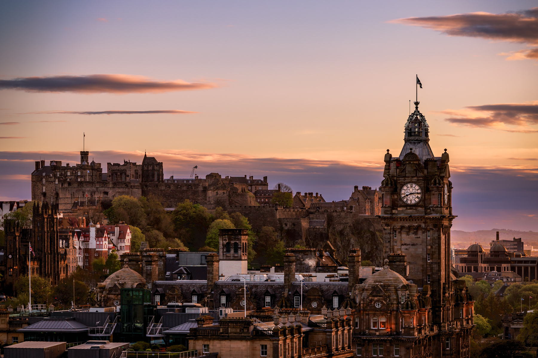
An Edinburgh Evening
Edinburgh Castle dominates the skyline above Scotland’s capital. This view from Calton Hill includes the clock tower of the Balmoral Hotel and the dense collection of Victorian and Georgian buildings that characterize central Edinburgh. Photographed at sunset in April 2026.
Berlin
I’ve had the pleasure of visiting Berlin twice. The first time was in the early 1980s and the second time in 2018. The transformation was dramatic.
Berlin Before the Fall of the Wall
I visited Berlin in the early 1980s. Berlin was then a divided city. I stayed in the Western zone near the Kurfurstendamm, which at the time was the heart of Berlin. I took a one day bus tour to the East. We crossed through Checkpoint Charlie. The bus was thoroughly searched by East German border guards. In contrast, the American military just let us pass freely.
The West was vibrant with shops, restaurants and people everywhere, In contrast, buildings in the East still showed signs of the bombing it received in the war. There were Soviet style memorials throughout East Berlin.
Our East German guide was openly dispirited and seemed to be reciting a script he was told to speak, especially when he spoke of “warm relations” with the then Soviet Union. At the end of the day, I was glad to be back in the West where I felt free and comfortable.
Berlin in 2018
Kurfurstendamm
In 2018, I went back to Berlin to see an undivided, transformed and reinvented Berlin. The German capital was still under construction 73 years after the end of WWII. I stayed near the Kurfurstendamm so I could compare my experience today with the early 1980s. My hotel — Pension Peters — is a small owner-managed hotel, where I felt more like a temporary resident in a nice Berlin neighborhood rather than a tourist.
I saw the transformation of Berlin immediately. The Kurfurstendamm is no longer the center of town. The heart of Berlin today is in the former East, which was a shambles when I was last there. The Kurfurstendamm is now a nice shopping street in lovely Berlin neighborhood called City West but is no longer the heart of the capital.
The Heart of Berlin
In 2018, Checkpoint Charlie was now nothing more than a tourist attraction with actor guards who, for a few Euros, will pose with you for a nice picture. There was even a “Checkpoint Charlie” McDonald’s across the street. It certainly no longer inspires fear.
The heart of Berlin is dominated by the Brandenburg Gate and government buildings, including the embassies of the four former occupying powers: the United States, Great Britain, France and Russia.
Berlin is no longer occupied but the former occupiers are nearby as if to say: “We are watching.” Each of the four embassies has a rich history.
The Soviet Union was first of the four major occupiers to move into a post-War embassy in Berlin. The Russian Embassy in Berlin was closed in 1941 when the two countries went to war. Its reconstruction was the first project of the post-war years in the East Berlin. The embassy’s official grand opening was held on the national holiday of the former USSR, on November 7, 1951. It’s Europe’s largest embassy which sends a message all by itself. After the fall of the Soviet Union in 1991, it became the Russian Embassy. (See also Rick Steves Berlin (p. 105). Avalon Publishing. Kindle Edition.)
The United Kingdom (UK) came next. The UK’s impressive new embassy was opened by Queen Elizabeth II on July 18, 2000.
France occupied its new embassy in October 2002. However, France formally opened it on January 23, 2003. That date was chosen as it was the 40th anniversary of the Élysée Treaty between Germany and France, declaring friendship between France and the former West Germany. French President Jacques Chirac presided. Marking the occasion, German Chancellor Gerhard Schröder and President Chirac issued a declaration affirming Franco-German friendship and their joint determination to “re-found Europe”.
The United States was the last of the four major occupiers to move into a post-War embassy in Berlin. The history of the U.S. Embassy in Berlin is especially complicated. During WWII, the U.S. Embassy in Berlin was severely damaged by Allied bombing. After the war, the embassy ended up just barely inside East Berlin in divided Berlin’s Soviet zone, straddling the demarcation between the Soviet and American sectors.
The Berlin Wall made the site of the former U.S. Embassy, still owned by the U.S. government, an inaccessible vacant lot. It was part of the security zone separating east and west Berliners. In 1967, the East German government demolished the ruins of the US Embassy building. However, the site became accessible after the Berlin Wall came down in November 1989. Even so, it remained a vacant lot until the 2004 groundbreaking for construction of a brand new U.S. Embassy. The newly constructed embassy opened on July 4, 2008.
The Brandenburg Gate is nearby. This is the center of Berlin. Since the 18th Century, the Brandenburg Gate has been a site for major historical events and today is an important symbol of the history of Europe and Germany.
Also nearby — and not to be missed — is Germany’s parliament — the Reichstag — which was opened in 1894 and remained in service until 1933, when it was severely damaged after being set on fire. The Reichstag fire occurred one month after Adolf Hitler was sworn in as Chancellor of Germany. After World War II, the building fell into disuse; the parliament of the German Democratic Republic (the Volkskammer) met in the Palast der Republik in East Berlin, while the parliament of the Federal Republic of Germany (the Bundestag) met in the Bundeshaus in Bonn.
The building was not properly restored until after German reunification on October 3, 1990. And what a glorious restoration it was. The German government chose British architect Norman Foster to lead the effort. Foster constructed is a large glass dome atop the Reichstag with a 360 degree view of the surrounding Berlin cityscape. The debating chamber of the Bundestag, the German parliament, can be seen below. A mirrored cone in the center of the dome directs sunlight into the building, and so that visitors can see the working of the chamber. The dome is open to the public and can be reached by climbing two steel, spiraling ramps that are reminiscent of a double helix. The Dome sends a message that the people are above the government, as was not the case during the Nazi era. After its completion in 1999, it once again became the meeting place of the German parliament: the modern Bundestag. The views are impressive. Entry is free but advance registration is required.
Other Berlin Sites
I also enjoyed visiting:
-
Hitler’s Bunker (Führerbunker), where Adolf Hitler committed suicide at the end of the war. It’s now an ordinary parking lot. Germany does not want to create a shrine out the place where Hitler perished.
-
Topography of Terror (Nazi Forced Labour Documentation Centre) has interesting exhibits documenting Nazi crimes. During the Nazi era, the headquarters of the Secret State Police, the SS and the Reich Security Main Office were located at the site.
-
The German History Museum for its candid exhibits about Hitler and the Nazis era.
-
Berlin-Hohenschönhausen Memorial, the site of the main political prison of the former East German Communist Ministry of State Security, the Stasi. I found the visit informative and chilling. East Germany went from one form of oppression to another form of oppression. It’s sad, terrifying and once again demonstrates what unchecked power can do.
-
Memorial to the Murdered Jews of Europe (Holocaust Memorial) has almost 3,000 symbolic pillars next to the U.S. Embassy in the heart of Berlin. It was designed by New York architect Peter Eisenman, who is Jewish. It opened in 2005. Eisenman explains that the “project manifests the instability inherent in what seems to be a system, here a rational grid, and its potential for dissolution in time.” The Memorial brings home the magnitude of the Holocaust.
Germany is creatively and thoughtfully reinventing its capital city. The transformation since the end of WWII is astounding.
It’s Important to Have Your Own Space on the Internet
Om on big publishing platforms:
No matter how often this happens, we don’t learn our lessons — we continue to till other people’s proverbial land and keep using their social spaces. Whether it is Facebook, Instagram, LinkedIn, or Medium, we get trapped in the big platforms because they dangle the one big carrot in front of our eyes: the reach, the audience, and the influence.
And we keep doing their bidding — they use our social networks, our work, and our attention — and, in the process, help make their networks gigantic and indispensable. We become pawns in their end game. And then they change the rules of the game — after all, if you own the league, you make the rules.
I have known the truth about social platforms. I quit Facebook and Instagram years ago, and candidly I am better for it. I don’t need 5000 friends — 15 good ones will do. And as far as sharing photos — I am happy that I have about a thousand people interested in my photographic work instead of 100,000 followers on Instagram.
Film: ‘The Art Dealer (L’antiquaire)’
The Art Dealer (L’antiquaire) is a beautiful 2015 French film about a young Parisian woman portrayed by Anna Sigalevitch. She’s searching for paintings stolen from her Jewish family during WWII.
Louis-Do de Lencquesaing who is in the hit French series Spiral does a nice job portraying the woman’s husband.
The cinema-photography is excellent and the slow uncovering of unflattering facts reveals what war brings out in human nature even among those not in power.
Finding Readers One at a Time
Sophia Efthimiatou, head of writer relations at Substack, explains that it’s ok to start writing with a small audience:
You would think known writers with large audiences have it easy here, but the pressure to succeed is felt more among them. The stakes are low if you are not at all known. There is no audience to lose, only one to gain. And gain you will. Perhaps when you start your only subscribers will be your best friend, your lonely neighbor, and your aunt–who can’t even read English. And then, one day, a fourth subscriber will roll in, a total stranger. That person will be there just to read you.
She’s right. One thoughtful reader who finds value in something you’ve written is enough.
Blog About Whatever You Want to Share
Ben Werdmuller on what you should write about on your blog:
Whatever you want to share. That’s the long answer and the short answer.
What you shouldn’t worry about is whether what you’re sharing is valuable. If you want to share it, it’s inherently valuable: a reflection of who you are and how you think about the world.
If you want to use it to build a business, then do that. If you want to share more about yourself, then do that. There are no wrong answers.
This is such a simple answer and the best one I’ve seen.
JungleDragon: Sharing Wildlife Photos
JungleDragon is a social wildlife community for fans of nature. It’s mission is to facilitate the creation of the largest resource of nature imagery on the planet. The site offers an engaging, social and friendly way to find and contribute images and other content.
The site was created by Ferdy Christant, a talented photographer. The site is free to use. I am a member and am enjoying it. If you’re interested you can follow me there.